Map Project: Scalable World Map (Coastlines/Rivers Complete)

1st edition? 2nd edition? It doesnt matter! Let's just talk Palladium Fantasy.

Moderators: Immortals, Supreme Beings, Old Ones

User avatar
Hotrod
Knight
Posts: 3429
Joined: Fri Apr 13, 2001 1:01 am
Location: Orion Arm, Milky Way Galaxy

Map Project: Scalable World Map (Coastlines/Rivers Complete)

Unread post by Hotrod »

One of the biggest frustrations I've had in my Palladium-based maps is inconsistency. All too often, there are subtle differences between one published map and another, or between a published map and the text it supports. This is is a particularly tricky issue with the Fantasy maps, where features like coastal shape, islands, and rivers are often very inconsistent.

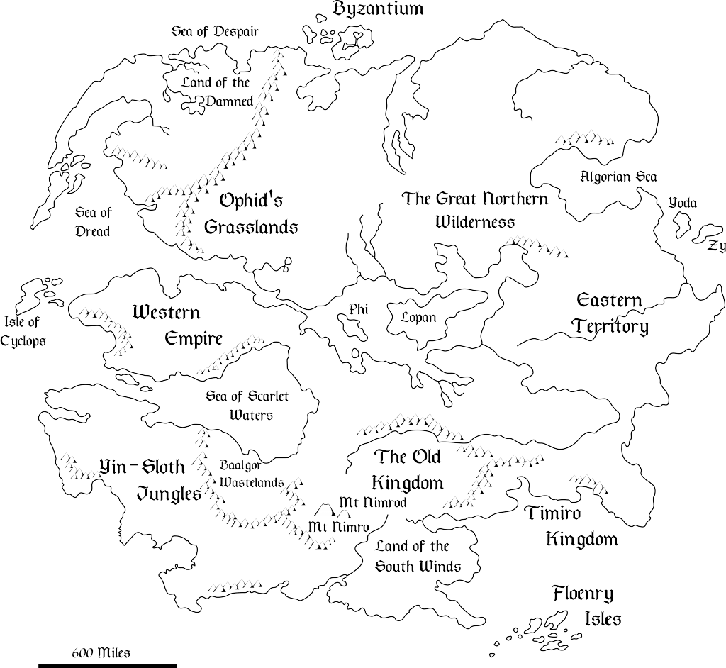
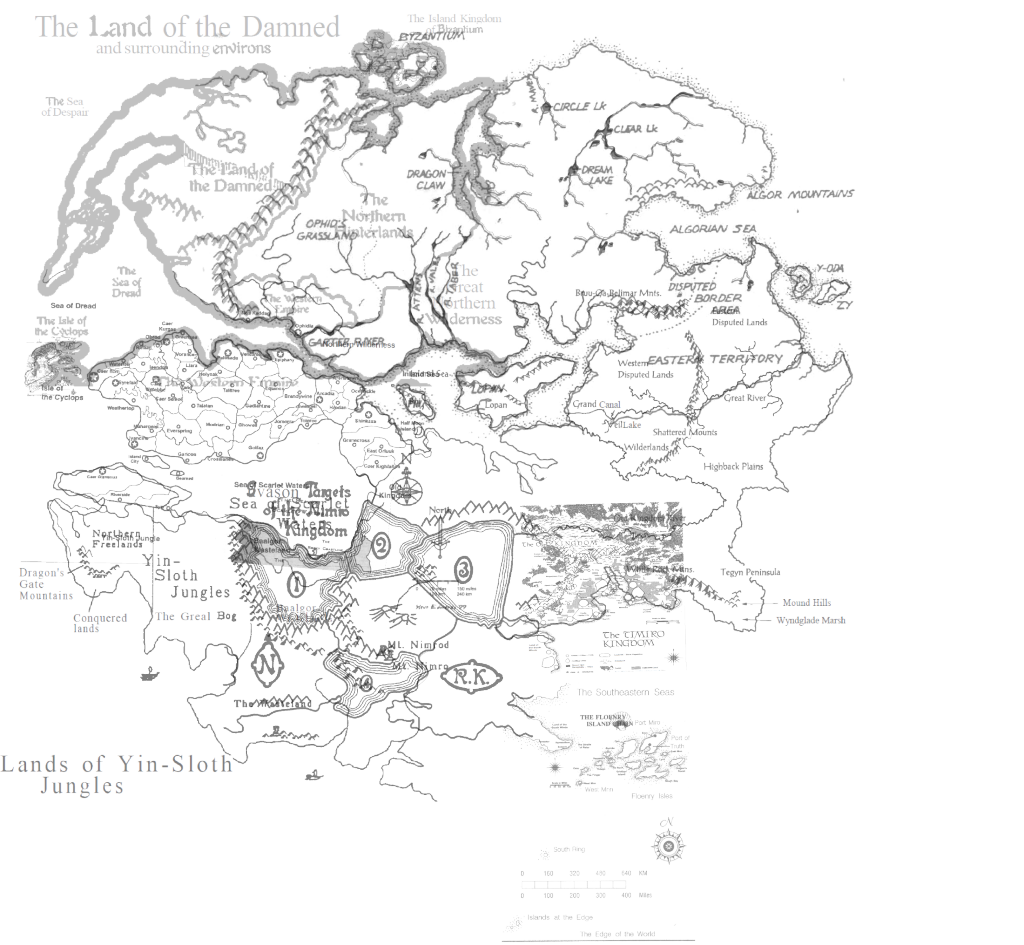
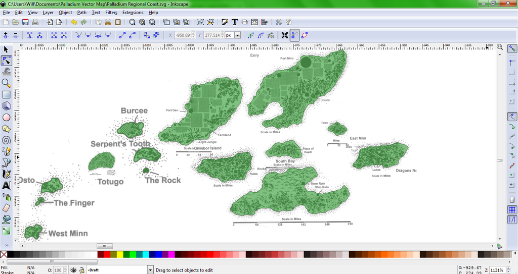
When I'm doing a local detail piece, such as my Kiridin map, I have to collage together upwards of half a dozen published maps. I can't reference them to real-life locations as I do in my Rifts maps, so I have to make innumerable judgment calls. I'm a canon-adherent mapmaker, so I try to make maps that match the published maps and text as precisely as possible. My guiding principle has always been that the map with the most detail gets priority. As a result, I have to do a lot of cross-checking.

I intend to solve this issue, both for me and any other would-be Palladium Fantasy cartographers, with the project I'm starting today:


A Scalable Palladium Fantasy World Map.


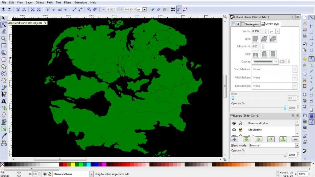
To the casual observer, this map will contain nothing new, nor will it have the kind of aesthetic appeal I try to put into most of my maps. In fact, it should end up looking pretty bare bones. This is intentional. Unlike my previous efforts, I will be making this map entirely in Inskape, a vector drawing program which allows me (and anyone else with the file) to zoom in and out without any "pixelating" effects. Anyone who wants to map a specific region could use this as a reliable and customizable starting point. It will also allow people to create prints as large as they desire while retaining a crisp look.

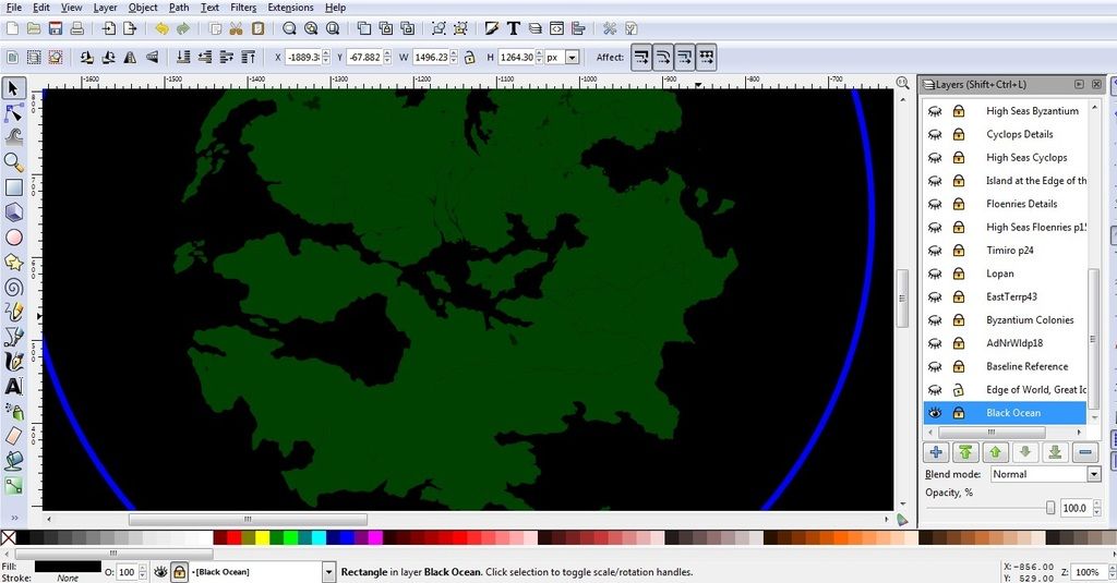
My intent is to render the coastlines, rivers, lakes, islands, and borders of Palladium as precisely as possible. This will match up the regional map features into a single, coherent image. The final product will be a template with lots of blank space, something a GM or other cartographer can fill.

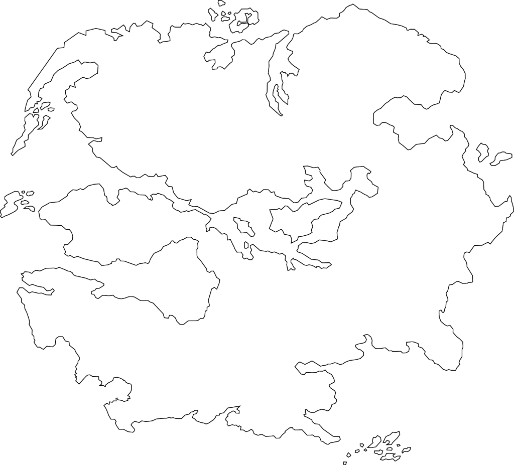
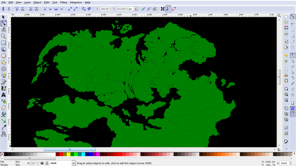
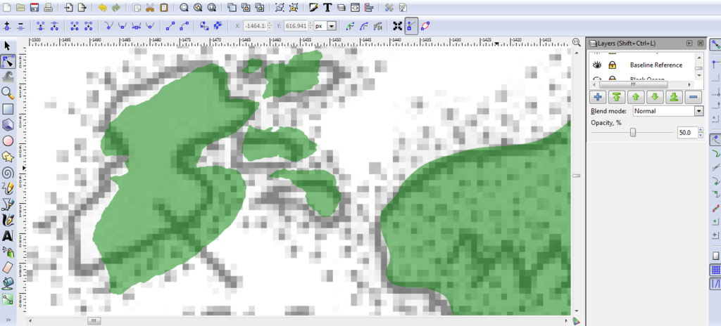
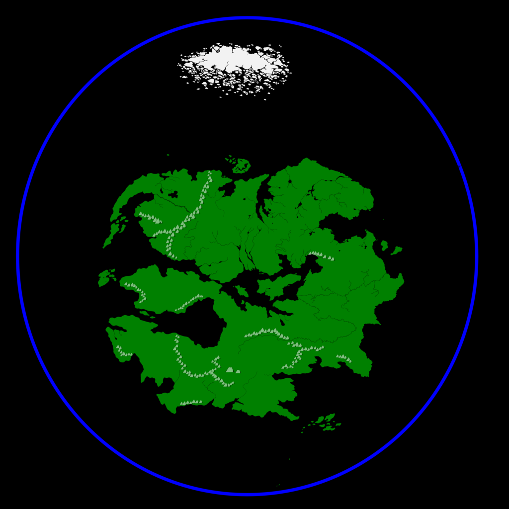
I just finished the first step in this process, which was a rough coastal trace of the original Palladium Map*. Although this map shows up in many places, I pulled p8 of Monsters and Animals, 2nd Edition. Each landmass consists of a straight-edged polygon.

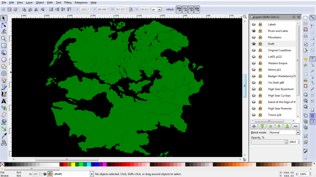
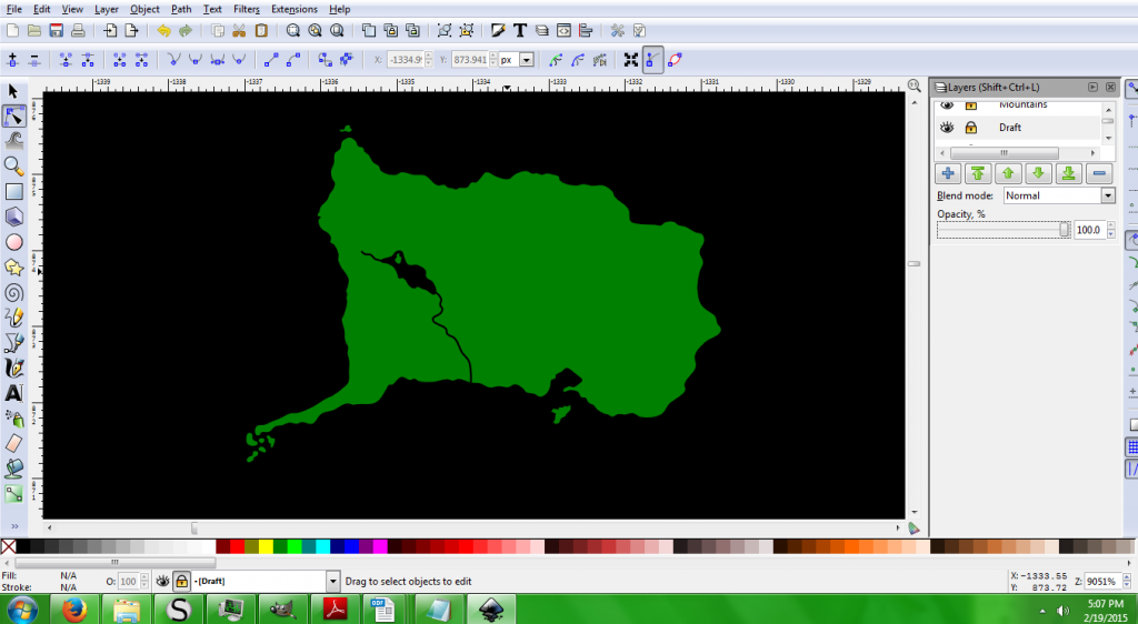
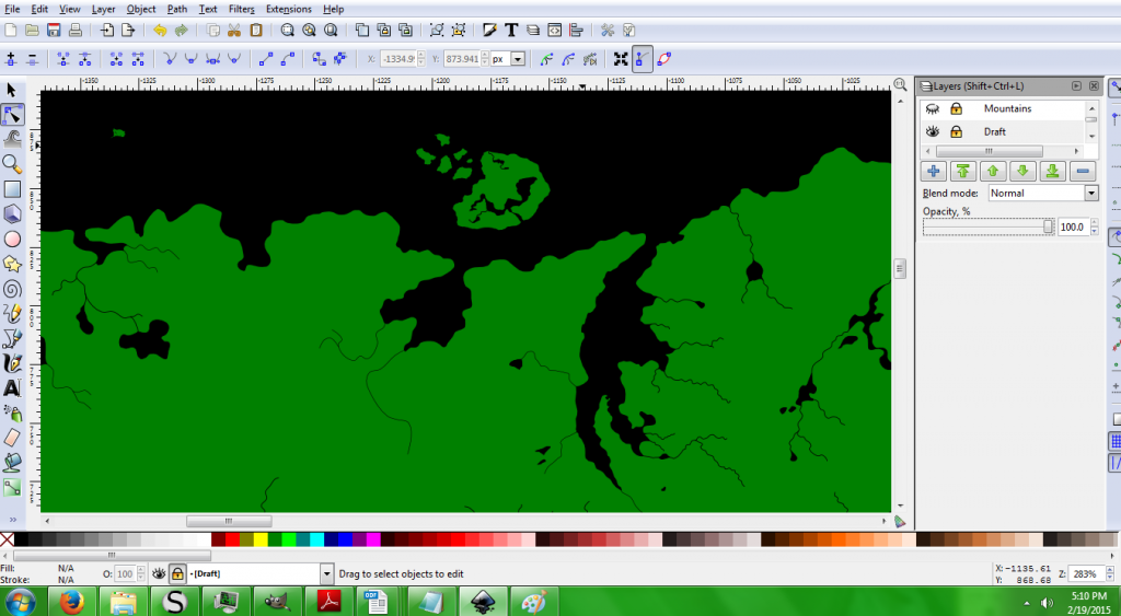
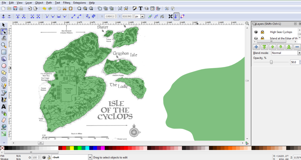
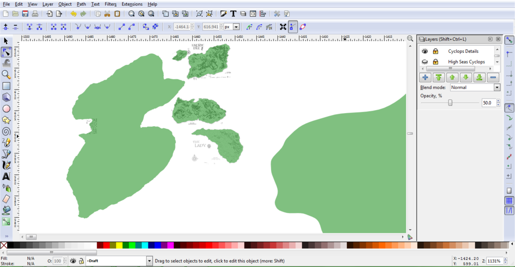
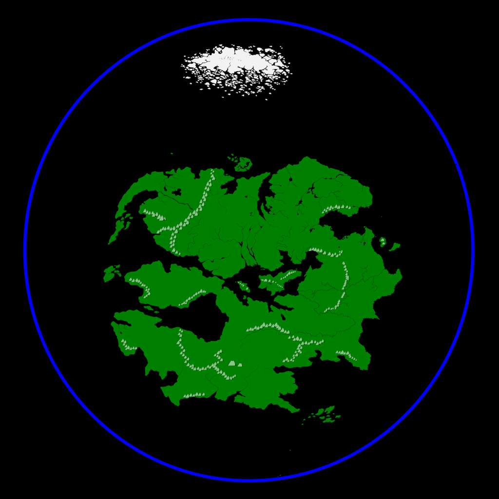
My next step is to curve the surfaces and smooth the corners to match this original map as well as is possible. After that, it's on to rivers, lakes, borders, and labels. I'll probably throw in some crude mountain markers for good measure.Then it gets really tricky. I'll have to collage in the regional maps, scale them to match the world map, re-shape the appropriate regions of the world map accordingly, and then add in regional features that don't show up on the global map. This is a "just for fun" project, so I'll work on it as my time/motivation permits.

*Note: my "in-progress" pictures will be bitmaps until the final product is finished, at which point I'll find some place I can put the vector file up for public download.
Last edited by Hotrod on Tue May 05, 2015 7:57 am, edited 4 times in total.
Hotrod
Author, Rifter Contributor, and Map Artist
Duty's Edge, a Rifts novel. Available as an ebook, PDF,or printed book.
Check out my maps here!
Also, check out my Instant NPC Generators!
Like what you see? There's more on my Patreon Page.
Image
User avatar
zyanitevp
Champion
Posts: 1744
Joined: Sun Feb 13, 2011 2:13 am
Comment: Check out our Twitch stream!
Location: Sekti-Abtu

Re: Map Project: Scalable World Map

Unread post by zyanitevp »

Looking forward to this
Broadcasting live twitchtv
My Twitter
Now Playing Savage Rifts as a Trimadore TechnoWizard
Image Image
User avatar
Glistam
Megaversal® Ambassador
Posts: 3631
Joined: Tue Apr 05, 2005 2:09 pm
Comment: The silent thief of Rozrehxeson.
Location: Connecticut
Contact:

Re: Map Project: Scalable World Map

Unread post by Glistam »

Sounds awesome! You're work has been excellent in the past and this sounds like it'll be a great resource.
Zerebus: "I like MDC. MDC is a hundred times better than SDC."

kiralon: "...the best way to kill an old one is to crash a moon into it."

Image

Temporal Wizard O.C.C. update 0.8 | Rifts random encounters
New Fire magic | New Temporal magic
Grim Gulf, the Nightlands version of Century Station

Let Chaos Magic flow in your campaigns.
User avatar
Hotrod
Knight
Posts: 3429
Joined: Fri Apr 13, 2001 1:01 am
Location: Orion Arm, Milky Way Galaxy

Re: Map Project: Scalable World Map

Unread post by Hotrod »

Update: I've fine-tuned the coast, added rivers and lakes, and I now have a map that is a precise match to the original and scalable to a huge range of sizes. Although I don't plan on matching mountains precisely, I threw some into this version, along with some labels, to make it a usable, if somewhat plain map. I started to fiddle with marking out national territories, but frankly, that was a pain, and it's not part of the intended scope of this project. I may work them into another version down the road.

Did I mention that you can blow up vector maps as big as you want? Here is a good example!
It's 3.5 MB and about 10,000 by 9,200 pixels, big enough to print on a 3' by 3' poster at 300 dpi resolution. Of course, it doesn't have much detail yet, and I haven't made any adjustments to match the regional sourcebook maps yet, so I wouldn't recommend going out and blowing your cash at Fedex to print this thing out. Just put it up on a 100-inch screen to see it in all its glory.

My next step is to pick out maps from the regional sourcebooks, Cut out everything but what I need (coasts, rivers, lakes, et cetera) scale them to match the global map, and place/rotate them to their best-fit position. Since many maps aren't listed in the quick find tables, I'll have to look through every book I have, page by page.

Given how I tend to get sucked into reading them, this could take a while.
Hotrod
Author, Rifter Contributor, and Map Artist
Duty's Edge, a Rifts novel. Available as an ebook, PDF,or printed book.
Check out my maps here!
Also, check out my Instant NPC Generators!
Like what you see? There's more on my Patreon Page.
Image
User avatar
zyanitevp
Champion
Posts: 1744
Joined: Sun Feb 13, 2011 2:13 am
Comment: Check out our Twitch stream!
Location: Sekti-Abtu

Re: Map Project: Scalable World Map

Unread post by zyanitevp »

Hotrod wrote:Update: I've fine-tuned the coast, added rivers and lakes, and I now have a map that is a precise match to the original and scalable to a huge range of sizes. Although I don't plan on matching mountains precisely, I threw some into this version, along with some labels, to make it a usable, if somewhat plain map. I started to fiddle with marking out national territories, but frankly, that was a pain, and it's not part of the intended scope of this project. I may work them into another version down the road.

Did I mention that you can blow up vector maps as big as you want? Here is a good example!
It's 3.5 MB and about 10,000 by 9,200 pixels, big enough to print on a 3' by 3' poster at 300 dpi resolution. Of course, it doesn't have much detail yet, and I haven't made any adjustments to match the regional sourcebook maps yet, so I wouldn't recommend going out and blowing your cash at Fedex to print this thing out. Just put it up on a 100-inch screen to see it in all its glory.

My next step is to pick out maps from the regional sourcebooks, Cut out everything but what I need (coasts, rivers, lakes, et cetera) scale them to match the global map, and place/rotate them to their best-fit position. Since many maps aren't listed in the quick find tables, I'll have to look through every book I have, page by page.

Given how I tend to get sucked into reading them, this could take a while.

Good baseline. Missing lots of mountains was my first reaction. Are you combining scales as well (they have differed across books) or using one specific one?
Broadcasting live twitchtv
My Twitter
Now Playing Savage Rifts as a Trimadore TechnoWizard
Image Image
User avatar
Hotrod
Knight
Posts: 3429
Joined: Fri Apr 13, 2001 1:01 am
Location: Orion Arm, Milky Way Galaxy

Re: Map Project: Scalable World Map

Unread post by Hotrod »

That's interesting. I threw in the mountains as a little something extra, but I thought I got them all. Where did I miss them? This version was a pretty straightforward recreation of the original map's major features; it's not good if I'm missing a lot right off the bat!

I guess I did miss the mountain on Y-oda. Anything else?

Doing the scale is gonna be a bit of a hassle. You're right that they're inconsistent. I need to make a ruler to match the scales precisely.
Hotrod
Author, Rifter Contributor, and Map Artist
Duty's Edge, a Rifts novel. Available as an ebook, PDF,or printed book.
Check out my maps here!
Also, check out my Instant NPC Generators!
Like what you see? There's more on my Patreon Page.
Image
User avatar
kiralon
Champion
Posts: 2805
Joined: Wed Jan 25, 2012 10:05 pm
Comment: Kill it with Fire.

Re: Map Project: Scalable World Map

Unread post by kiralon »

The mountains through the eastern territories, even though they are about 2300 ft.
User avatar
Lukterran
Adventurer
Posts: 642
Joined: Wed Jan 01, 2003 2:01 am
Location: The Kingdom of Farr

Re: Map Project: Scalable World Map

Unread post by Lukterran »

kiralon wrote:The mountains through the eastern territories, even though they are about 2300 ft.


That isn't a mountain that is a hill.
User avatar
Hotrod
Knight
Posts: 3429
Joined: Fri Apr 13, 2001 1:01 am
Location: Orion Arm, Milky Way Galaxy

Re: Map Project: Scalable World Map

Unread post by Hotrod »

There is no broadly-accepted definition for what constitutes a mountain or a hill. It's all a question of perspective. What a guy in Denver calls a hill, a guy in Florida might call a mountain.

In this case, those features weren't included because they weren't in the original world map; they're in the Eastern Territory book. I may throw them in later, but they're an extra feature. What matters most to me is getting the coasts, rivers, lakes, and islands right.
Hotrod
Author, Rifter Contributor, and Map Artist
Duty's Edge, a Rifts novel. Available as an ebook, PDF,or printed book.
Check out my maps here!
Also, check out my Instant NPC Generators!
Like what you see? There's more on my Patreon Page.
Image
User avatar
Thinyser
Knight
Posts: 4119
Joined: Wed Nov 17, 2004 7:58 pm
Comment: "Think of how stupid the average person is, and realize half of them are stupider than that."
~George Carlin
Location: Sioux Falls SD

Re: Map Project: Scalable World Map

Unread post by Thinyser »

I applaud your effort and cannot wait to see the fruits of your labor!
"We live in a world where people use severed plant genitals to express affection.
Rifts is really not much weirder than that." ~~Killer Cyborg

"If we let technical problems scare us away from doing anything, humanity would still be in the trees flinging poo at each other."~~Killer Cyborg

"Everything that breeds is a threat."~~Killer Cyborg
User avatar
kiralon
Champion
Posts: 2805
Joined: Wed Jan 25, 2012 10:05 pm
Comment: Kill it with Fire.

Re: Map Project: Scalable World Map

Unread post by kiralon »

Hotrod wrote:There is no broadly-accepted definition for what constitutes a mountain or a hill. It's all a question of perspective. What a guy in Denver calls a hill, a guy in Florida might call a mountain.

In this case, those features weren't included because they weren't in the original world map; they're in the Eastern Territory book. I may throw them in later, but they're an extra feature. What matters most to me is getting the coasts, rivers, lakes, and islands right.

and you have done a great job, I just thought I'd mention them because I thought they were in the latest map, and the map makes them look as important as the one that border the disputed lands and the gnw. I never realised they were that small until I read that section specifically and at 2300ft id call them hills, but as definitions are different (I do believe the scots don't believe in mountains and everything is a hill e.g. http://en.wikipedia.org/wiki/Torridon_Hills) a mountain can be as small as 300ft, so what hotrod says is correct, It depends on who you talk to.

Will be cool when finished, ill print out some more a1 maps again.
User avatar
Hotrod
Knight
Posts: 3429
Joined: Fri Apr 13, 2001 1:01 am
Location: Orion Arm, Milky Way Galaxy

Re: Map Project: Scalable World Map

Unread post by Hotrod »

You've got me curious now. Which version do you count as the 'latest map'? Other than the one in Bill Coffin's Northern Hinterlands book (which may be re-printed in the LotD books, I'd have to check), I'm not aware of a newer world map. Or is that the one you mean?
Hotrod
Author, Rifter Contributor, and Map Artist
Duty's Edge, a Rifts novel. Available as an ebook, PDF,or printed book.
Check out my maps here!
Also, check out my Instant NPC Generators!
Like what you see? There's more on my Patreon Page.
Image
User avatar
kiralon
Champion
Posts: 2805
Joined: Wed Jan 25, 2012 10:05 pm
Comment: Kill it with Fire.

Re: Map Project: Scalable World Map

Unread post by kiralon »

hmm, I thought it was the library of bletherad, but im not near my books atm, I will check again.
User avatar
Hotrod
Knight
Posts: 3429
Joined: Fri Apr 13, 2001 1:01 am
Location: Orion Arm, Milky Way Galaxy

Re: Map Project: Scalable World Map

Unread post by Hotrod »

Minor update today. I spent a couple of hours doing detail work on the northern coast of the Great Northern Wilderness from Dragon's Claw to Zy and Y-Oda using the map on p18 of the Wolfen Empire book. During that process, I also discovered something I'd never noticed before: six small islands just off the mainland coast, mostly in the Algorian sea.

I also did some work on the rivers and lakes that drain out through the northern coast. This book's maps have well-defined river systems with a natural look (unlike the Old Kingdom River)

Tonight was the first time I touched this project in about a month, as I spent most of my free time finishing and defending my master's thesis (Yay!). I'll be picking up the pace some now, but this phase of detailing coastlines is very time-consuming as I work through each separate region.
Hotrod
Author, Rifter Contributor, and Map Artist
Duty's Edge, a Rifts novel. Available as an ebook, PDF,or printed book.
Check out my maps here!
Also, check out my Instant NPC Generators!
Like what you see? There's more on my Patreon Page.
Image
Tyberius
Wanderer
Posts: 80
Joined: Wed Mar 21, 2012 1:25 pm
Location: Los Angeles, CA

Re: Map Project: Scalable World Map

Unread post by Tyberius »

I just saw this post. I wanted to do something similar 2 years ago. Went over to Cartographer's Guild, and read up about different programs and applications. Tried a few, but didn't get anywhere. I'd love to offer up some help, and tag team something like this, but there isn't enough time. Best of luck to you, and I'll be following your progress. Keep up the good work.
User avatar
Hotrod
Knight
Posts: 3429
Joined: Fri Apr 13, 2001 1:01 am
Location: Orion Arm, Milky Way Galaxy

Re: Map Project: Scalable World Map

Unread post by Hotrod »

The Cartographers Guild is a great site, though most of the tutorials are focused on making a map from scratch. I haven't found any good guides for what I'm doing, so I'm plodding my way through by trial and error. I've got a technique down now that's working, though it is very time-consuming. The tricky part is making the judgment calls of where one source map takes over from another. I'd be happy to hand off some of it, but I don't think it's worth it to learn Inkscape just for one project.

Status:
Here's an in-progress screenshot. After a few more hours on it today, I finished the coasts, lakes, rivers, and small islands of the Great Northern Wilderness from Dragon's Claw down to the Disputed lands and the Inland Sea's north coast from the Eastern Territories border to the southern edge of the Great Barrier Mountains. The Wolfen Empire p18 map was my main reference map for the GNW. Right now, I'm working the Eastern Territories' east coast using the p43 map from that book.

Incidentally, the Eastern Territories book is a book that just screams for a map that ties everything together. It's got loads of city-scale maps that are pretty good, but the regional maps are a problem. The book has about a dozen regional maps, and most of them highlight one little region's territory without showing the other territories in context. It might be a good candidate for a later mapping project.
Hotrod
Author, Rifter Contributor, and Map Artist
Duty's Edge, a Rifts novel. Available as an ebook, PDF,or printed book.
Check out my maps here!
Also, check out my Instant NPC Generators!
Like what you see? There's more on my Patreon Page.
Image
User avatar
zyanitevp
Champion
Posts: 1744
Joined: Sun Feb 13, 2011 2:13 am
Comment: Check out our Twitch stream!
Location: Sekti-Abtu

Re: Map Project: Scalable World Map

Unread post by zyanitevp »

Looking awesome!
Broadcasting live twitchtv
My Twitter
Now Playing Savage Rifts as a Trimadore TechnoWizard
Image Image
User avatar
Hotrod
Knight
Posts: 3429
Joined: Fri Apr 13, 2001 1:01 am
Location: Orion Arm, Milky Way Galaxy

Re: Map Project: Scalable World Map

Unread post by Hotrod »

Status: The Eastern Territory coast and rivers are complete, and I've collected and assembled 16 of the best canon regional maps I can find. Here is a screenshot of the current version. Here is a screenshot of the regional source maps mashed together.

I have 16 source maps included in a dozen separate layers in the file. Some of these maps map does not match up well to other canon maps. Timiro and the Yin-Sloth Jungles' regional maps were particularly troublesome. I had to stretch and rotate these maps to get a rough fit. In the case of the Yin-Sloth, no stretching or rotating could make a good enough fit, so will probably just re-adjust the reference map as I trace its coast. This should allow for local details to come through, while retaining the original shape. Also, some regions have no canon rivers, which is a little weird.

What I'm missing:
-New lands mentioned in the new Byzantium book's teaser.
-I don't have a regional map of the Land of South Winds. Anyone know where I can find one?
-Western Empire mentions a small island chain far to the west of the Isle of the Cyclops, but they're not well-described or placed.
-The Edge of the World is only depicted in maps as a straight East-West line, but I've heard accounts on the boards of Kevin describing it otherwise. What's the canon word on this?

Next step: Timiro!
Hotrod
Author, Rifter Contributor, and Map Artist
Duty's Edge, a Rifts novel. Available as an ebook, PDF,or printed book.
Check out my maps here!
Also, check out my Instant NPC Generators!
Like what you see? There's more on my Patreon Page.
Image
User avatar
Hotrod
Knight
Posts: 3429
Joined: Fri Apr 13, 2001 1:01 am
Location: Orion Arm, Milky Way Galaxy

Re: Map Project: Scalable World Map

Unread post by Hotrod »

The main continent's coasts, rivers, and lakes are done! I've worked my way all around the continent. Here is a screenshot of the current version.

The next step is to work all the islands, from Lemaria in the north to the Islands at the Edge of the World in the south.
Hotrod
Author, Rifter Contributor, and Map Artist
Duty's Edge, a Rifts novel. Available as an ebook, PDF,or printed book.
Check out my maps here!
Also, check out my Instant NPC Generators!
Like what you see? There's more on my Patreon Page.
Image
User avatar
zyanitevp
Champion
Posts: 1744
Joined: Sun Feb 13, 2011 2:13 am
Comment: Check out our Twitch stream!
Location: Sekti-Abtu

Re: Map Project: Scalable World Map

Unread post by zyanitevp »

Hotrod wrote:Status: The Eastern Territory coast and rivers are complete, and I've collected and assembled 16 of the best canon regional maps I can find. Here is a screenshot of the current version. Here is a screenshot of the regional source maps mashed together.

I have 16 source maps included in a dozen separate layers in the file. Some of these maps map does not match up well to other canon maps. Timiro and the Yin-Sloth Jungles' regional maps were particularly troublesome. I had to stretch and rotate these maps to get a rough fit. In the case of the Yin-Sloth, no stretching or rotating could make a good enough fit, so will probably just re-adjust the reference map as I trace its coast. This should allow for local details to come through, while retaining the original shape. Also, some regions have no canon rivers, which is a little weird.

What I'm missing:
-New lands mentioned in the new Byzantium book's teaser.
-I don't have a regional map of the Land of South Winds. Anyone know where I can find one?
-Western Empire mentions a small island chain far to the west of the Isle of the Cyclops, but they're not well-described or placed.
-The Edge of the World is only depicted in maps as a straight East-West line, but I've heard accounts on the boards of Kevin describing it otherwise. What's the canon word on this?

Next step: Timiro!

Not aware of any regional map of South Winds yet. You may want to reach out to Prysus.
Canon on the Edge is that it surrounds Palladium, although that sounds like it is about to change with Byzantium.
Broadcasting live twitchtv
My Twitter
Now Playing Savage Rifts as a Trimadore TechnoWizard
Image Image
User avatar
Hotrod
Knight
Posts: 3429
Joined: Fri Apr 13, 2001 1:01 am
Location: Orion Arm, Milky Way Galaxy

Re: Map Project: Scalable World Map

Unread post by Hotrod »

Mini-update: I've done a little revising to the coast of the Land of South Winds (Thanks for the input, Prysus!) and I've started work on the islands. Byzantium is done, Lemaria is done, and I've added in the three larger islands introduced in Island at the Edge of the World.

Already I can see the benefits of this approach. Here is a zoomed-in screenshot of Lemaria. Here is a screenshot of the northern coast. Lemaria is the little dot of an island off to the left by itself. Pretty neat!

I still need to retouch the Cyclops archipeligo, Phi and Lopan, Zy and Y-Oda, the Floenry Isles, and a few minor coastal islands here and there. Islands are taking significant amounts of time because many of them have very zoomed-in detail maps. I want to capture these details at the highest resolution I can.

The overall end is in sight, though. At this point, the only other change I'm looking to make with the mainland is adding in the mountains in the Eastern Territories. The vector file, as it stands now, is just over 8 MB.

Progress will be slower for the next week or two as I work on a little side-project that has come up.
Hotrod
Author, Rifter Contributor, and Map Artist
Duty's Edge, a Rifts novel. Available as an ebook, PDF,or printed book.
Check out my maps here!
Also, check out my Instant NPC Generators!
Like what you see? There's more on my Patreon Page.
Image
User avatar
pblackcrow
Champion
Posts: 2541
Joined: Sat Jul 13, 2002 1:01 am
Location: On Earth
Contact:

Re: Map Project: Scalable World Map

Unread post by pblackcrow »

Hey, do you plan on doing the islands west of the isle of Cyclopes that are talked of in WE?
Ankh, udja, seneb.
User avatar
Hotrod
Knight
Posts: 3429
Joined: Fri Apr 13, 2001 1:01 am
Location: Orion Arm, Milky Way Galaxy

Re: Map Project: Scalable World Map

Unread post by Hotrod »

Yes, I do, though their size, shape, and precise location will be little more than an educated guess. That'll probably be the last set of islands I do.
Hotrod
Author, Rifter Contributor, and Map Artist
Duty's Edge, a Rifts novel. Available as an ebook, PDF,or printed book.
Check out my maps here!
Also, check out my Instant NPC Generators!
Like what you see? There's more on my Patreon Page.
Image
User avatar
Whiskeyjack
Adventurer
Posts: 687
Joined: Wed Feb 04, 2015 7:35 pm
Location: Thunder Bay, NW Ontario

Re: Map Project: Scalable World Map

Unread post by Whiskeyjack »

Awesome job Hotrod!
Anyone else notice the bay next to Dragons Claw looks like a dragons head breathing fire (the rivers)?
User avatar
zyanitevp
Champion
Posts: 1744
Joined: Sun Feb 13, 2011 2:13 am
Comment: Check out our Twitch stream!
Location: Sekti-Abtu

Re: Map Project: Scalable World Map

Unread post by zyanitevp »

Great work! Looking forward to the final product
Broadcasting live twitchtv
My Twitter
Now Playing Savage Rifts as a Trimadore TechnoWizard
Image Image
User avatar
Hotrod
Knight
Posts: 3429
Joined: Fri Apr 13, 2001 1:01 am
Location: Orion Arm, Milky Way Galaxy

Re: Map Project: Scalable World Map

Unread post by Hotrod »

Update: Islands are taking longer than I thought they would. Part of this is because I dropped everything to make the Bizantium map, but part of it is the extra work these small features often involve. The problem is that many of these islands have several maps defining them. The Cyclops archipeligo is a good example.

Here's the vector map with the the world map superimposed, which gives me the location of the archipeligo.
Here's the vector map with the cyclops archipeligo map from High Seas superimposed, which gives me the relative location and rough shape of each island.
Here is the vector map with the individual island maps superimposed, which gives me the final coastal shape of each island, as well as a bit more local detail on the Gryphon's Nest Bay.

All three levels of source maps are necessary to make the vector map. Originally, I thought that the archipeligo map was a precise match to the individual island maps. I was wrong, and I wound up tracing all three versions. That was a motivation test.

Lesson learned. For the Floenries, I'll line up all the source maps first and then do a single refinement.
Hotrod
Author, Rifter Contributor, and Map Artist
Duty's Edge, a Rifts novel. Available as an ebook, PDF,or printed book.
Check out my maps here!
Also, check out my Instant NPC Generators!
Like what you see? There's more on my Patreon Page.
Image
User avatar
pblackcrow
Champion
Posts: 2541
Joined: Sat Jul 13, 2002 1:01 am
Location: On Earth
Contact:

Re: Map Project: Scalable World Map

Unread post by pblackcrow »

For the Floenrys I would use the map in the Island at the Edge of the World as a good comparison contrast. But that's me.
Ankh, udja, seneb.
User avatar
Hotrod
Knight
Posts: 3429
Joined: Fri Apr 13, 2001 1:01 am
Location: Orion Arm, Milky Way Galaxy

Re: Map Project: Scalable World Map

Unread post by Hotrod »

Oh, absolutely, the Edge of the World map shows their position nicely, but I don't think it shows the individual definition as well as the individual island maps. I won't know for sure until I start lining them up.

I did Y-Oda and Zy today. Zy was a little annoying; High Seas just points to a dot on a small-scale world map. The best-definition map for Zy I could find was the Eastern Territories map.

I'll probably tackle the Inland Sea next.
Hotrod
Author, Rifter Contributor, and Map Artist
Duty's Edge, a Rifts novel. Available as an ebook, PDF,or printed book.
Check out my maps here!
Also, check out my Instant NPC Generators!
Like what you see? There's more on my Patreon Page.
Image
User avatar
zyanitevp
Champion
Posts: 1744
Joined: Sun Feb 13, 2011 2:13 am
Comment: Check out our Twitch stream!
Location: Sekti-Abtu

Re: Map Project: Scalable World Map

Unread post by zyanitevp »

Congrats on the Bizantium map- great work!
I find it ironic that both people I commissioned for map work end up in the same book, you and Tad.
Good luck with the islands- they have moved on many maps in the past- have you checked with Wayne or Kevin for proper placement?
Broadcasting live twitchtv
My Twitter
Now Playing Savage Rifts as a Trimadore TechnoWizard
Image Image
User avatar
Hotrod
Knight
Posts: 3429
Joined: Fri Apr 13, 2001 1:01 am
Location: Orion Arm, Milky Way Galaxy

Re: Map Project: Scalable World Map

Unread post by Hotrod »

Thanks! Yes, you should get puppet-master credit for the two full-page maps in Bizantium. Tad's came out great in the sneak preview!

The Inland Sea is the pivot point for the whole continent. It took some shimmying to make things fit in a way that satisfied me, but the island placement looks ok now. The Floenries are going to be the next big hurdle. Then I'll start working on The Great Ice Shelf, the Edge of the World, the Islands at the Edge of the World, and some of those tiny little islands that pop up here and there on the regional maps. I've been slacking a bit on this project and focusing on some odds and ends for a Land of South Winds map, but I'll keep plugging away on it.
Hotrod
Author, Rifter Contributor, and Map Artist
Duty's Edge, a Rifts novel. Available as an ebook, PDF,or printed book.
Check out my maps here!
Also, check out my Instant NPC Generators!
Like what you see? There's more on my Patreon Page.
Image
User avatar
Glistam
Megaversal® Ambassador
Posts: 3631
Joined: Tue Apr 05, 2005 2:09 pm
Comment: The silent thief of Rozrehxeson.
Location: Connecticut
Contact:

Re: Map Project: Scalable World Map

Unread post by Glistam »

What if those islands being in different places in different maps isn't a typical Palladium error, but rather by design? It is a world of magic, after all. Maybe those islands move around a little?
Zerebus: "I like MDC. MDC is a hundred times better than SDC."

kiralon: "...the best way to kill an old one is to crash a moon into it."

Image

Temporal Wizard O.C.C. update 0.8 | Rifts random encounters
New Fire magic | New Temporal magic
Grim Gulf, the Nightlands version of Century Station

Let Chaos Magic flow in your campaigns.
User avatar
Hotrod
Knight
Posts: 3429
Joined: Fri Apr 13, 2001 1:01 am
Location: Orion Arm, Milky Way Galaxy

Re: Map Project: Scalable World Map

Unread post by Hotrod »

Glistam wrote:What if those islands being in different places in different maps isn't a typical Palladium error, but rather by design? It is a world of magic, after all. Maybe those islands move around a little?


Like the Elemental Isle (in High Seas, 1st ed, I think?)? That's an interesting interpretation. The precise shapes probably shouldn't change, but their locations could? That's not hard to do. The Green Map (as I'm coming to call it) has each land mass as a separate object, so a cartographer (or GM) could move them around to his/her heart's content.
Hotrod
Author, Rifter Contributor, and Map Artist
Duty's Edge, a Rifts novel. Available as an ebook, PDF,or printed book.
Check out my maps here!
Also, check out my Instant NPC Generators!
Like what you see? There's more on my Patreon Page.
Image
User avatar
pblackcrow
Champion
Posts: 2541
Joined: Sat Jul 13, 2002 1:01 am
Location: On Earth
Contact:

Re: Map Project: Scalable World Map

Unread post by pblackcrow »

Hotrod wrote:Thanks! Yes, you should get puppet-master credit for the two full-page maps in Bizantium. Tad's came out great in the sneak preview!

The Inland Sea is the pivot point for the whole continent. It took some shimmying to make things fit in a way that satisfied me, but the island placement looks ok now. The Floenries are going to be the next big hurdle. Then I'll start working on The Great Ice Shelf, the Edge of the World, the Islands at the Edge of the World, and some of those tiny little islands that pop up here and there on the regional maps. I've been slacking a bit on this project and focusing on some odds and ends for a Land of South Winds map, but I'll keep plugging away on it.

a bit of a suggestion. Look at Western Empire and Wolfen Empire.
Ankh, udja, seneb.
User avatar
Hotrod
Knight
Posts: 3429
Joined: Fri Apr 13, 2001 1:01 am
Location: Orion Arm, Milky Way Galaxy

Re: Map Project: Scalable World Map

Unread post by Hotrod »

pblackcrow wrote:
Hotrod wrote:Thanks! Yes, you should get puppet-master credit for the two full-page maps in Bizantium. Tad's came out great in the sneak preview!

The Inland Sea is the pivot point for the whole continent. It took some shimmying to make things fit in a way that satisfied me, but the island placement looks ok now. The Floenries are going to be the next big hurdle. Then I'll start working on The Great Ice Shelf, the Edge of the World, the Islands at the Edge of the World, and some of those tiny little islands that pop up here and there on the regional maps. I've been slacking a bit on this project and focusing on some odds and ends for a Land of South Winds map, but I'll keep plugging away on it.

a bit of a suggestion. Look at Western Empire and Wolfen Empire.


Good suggestion! I've already go those and a map from Eastern Territory collaged together with a whole mess of other regional maps in a couple dozen reference layers. The approximate shapes are right, but they're far from a perfect fit.

I've madea bit of progress, but mostly for the last several days I've been helping the wife and kids through a very nasty stomach bug.
Hotrod
Author, Rifter Contributor, and Map Artist
Duty's Edge, a Rifts novel. Available as an ebook, PDF,or printed book.
Check out my maps here!
Also, check out my Instant NPC Generators!
Like what you see? There's more on my Patreon Page.
Image
User avatar
Hotrod
Knight
Posts: 3429
Joined: Fri Apr 13, 2001 1:01 am
Location: Orion Arm, Milky Way Galaxy

Re: Map Project: Scalable World Map

Unread post by Hotrod »

Update: The Inland Sea, Phi, and Lopan are done. I wound up using the world map for island and coast placement, Eastern Territory map for the shape of Phi and Lopan, the Western Empire book for the shape of Half Moon Island, and the Wolfen Empire map for a few extra tiny islands, and a pair of rivers on Lopan. I also placed an elliptical Edge of the World around the continent based on its description in the new Bizantium book.

Here's a screenshot of the current version.

Thanks to Bizantium, I still need to add in the Great Ice Shelf, but I think I'll tackle the Floenries next. I've been putting them off too long.
Hotrod
Author, Rifter Contributor, and Map Artist
Duty's Edge, a Rifts novel. Available as an ebook, PDF,or printed book.
Check out my maps here!
Also, check out my Instant NPC Generators!
Like what you see? There's more on my Patreon Page.
Image
User avatar
Hotrod
Knight
Posts: 3429
Joined: Fri Apr 13, 2001 1:01 am
Location: Orion Arm, Milky Way Galaxy

Re: Map Project: Scalable World Map

Unread post by Hotrod »

EDIT: Fixed the link.
It's been almost a month since my last update; I've been a bit distracted by a couple of side projects like my Land of the Damned map, the Glen Evans special map, and an ongoing Land of South Winds map project.

Update: The Floenries are done. Each individual island was superimposed over the regional map (which was in turn superimposed over the world map for correct placement/scaling). Here is a screenshot of the completed Floenries coastlines. The green is the vectorized map. I've included the superimposed individual islands as a reference, but these are in a separate (and concealable)

An interesting oddity I've noticed: There are no rivers or streams marked in the Floenries.

I've started working through the Islands at the Edge of the World, and I still need to add in the Great Ice Shelf, but at this point, the "classic" world map is just about done. The current land mass layer has over 5500 nodes, and I'll probably be over 6,000 by the time I'm done. The file size is just short of 40 MB, but a lot of that is the source map layers, which I will probably not include in the download version, as I don't want to deal with copyright issues (I might include a world map from the free Bizantium download teaser).

Anyone know a place I can post an .svg file for downloading?
Hotrod
Author, Rifter Contributor, and Map Artist
Duty's Edge, a Rifts novel. Available as an ebook, PDF,or printed book.
Check out my maps here!
Also, check out my Instant NPC Generators!
Like what you see? There's more on my Patreon Page.
Image
User avatar
zyanitevp
Champion
Posts: 1744
Joined: Sun Feb 13, 2011 2:13 am
Comment: Check out our Twitch stream!
Location: Sekti-Abtu

Re: Map Project: Scalable World Map

Unread post by zyanitevp »

Hotrod wrote:
EDIT: Fixed the link.
It's been almost a month since my last update; I've been a bit distracted by a couple of side projects like my Land of the Damned map, the Glen Evans special map, and an ongoing Land of South Winds map project.

Update: The Floenries are done. Each individual island was superimposed over the regional map (which was in turn superimposed over the world map for correct placement/scaling). Here is a screenshot of the completed Floenries coastlines. The green is the vectorized map. I've included the superimposed individual islands as a reference, but these are in a separate (and concealable)

An interesting oddity I've noticed: There are no rivers or streams marked in the Floenries.

I've started working through the Islands at the Edge of the World, and I still need to add in the Great Ice Shelf, but at this point, the "classic" world map is just about done. The current land mass layer has over 5500 nodes, and I'll probably be over 6,000 by the time I'm done. The file size is just short of 40 MB, but a lot of that is the source map layers, which I will probably not include in the download version, as I don't want to deal with copyright issues (I might include a world map from the free Bizantium download teaser).

Anyone know a place I can post an .svg file for downloading?


Sounds like a call to Palladium to find out where the rivers in the Floenry Isles are.....
So glad you are doing this- cannot wait for the definitive map to be finished!!
Broadcasting live twitchtv
My Twitter
Now Playing Savage Rifts as a Trimadore TechnoWizard
Image Image
User avatar
Hotrod
Knight
Posts: 3429
Joined: Fri Apr 13, 2001 1:01 am
Location: Orion Arm, Milky Way Galaxy

Re: Map Project: Scalable World Map

Unread post by Hotrod »

Well, I'll probably make it more of a "show and tell" at Open House if I can get a few minutes of Kevin or Wayne's time. This isn't an official product (yet?), and it may be irrelevant or redundant if Tad Davis winds up doing a poster project and creates his own version.

The Western Empire is the biggest watershed offender; that huge region doesn't have a single canon river or lake mapped. There are plenty of regions where rivers and lakes are rarer than one might expect, especially in the south and western parts of the world. Then there's the Old Kingdom River, a river that runs toward and through two mountain ranges, turning away from the nearby ocean in between. Those Old Kingdom civil engineers must have put in some serious overtime to make that happen.

These little idiosyncrasies are part of what makes this project fun and interesting to me.
Hotrod
Author, Rifter Contributor, and Map Artist
Duty's Edge, a Rifts novel. Available as an ebook, PDF,or printed book.
Check out my maps here!
Also, check out my Instant NPC Generators!
Like what you see? There's more on my Patreon Page.
Image
User avatar
kiralon
Champion
Posts: 2805
Joined: Wed Jan 25, 2012 10:05 pm
Comment: Kill it with Fire.

Re: Map Project: Scalable World Map

Unread post by kiralon »

Hotrod wrote:Well, I'll probably make it more of a "show and tell" at Open House if I can get a few minutes of Kevin or Wayne's time. This isn't an official product (yet?), and it may be irrelevant or redundant if Tad Davis winds up doing a poster project and creates his own version.

The Western Empire is the biggest watershed offender; that huge region doesn't have a single canon river or lake mapped. There are plenty of regions where rivers and lakes are rarer than one might expect, especially in the south and western parts of the world. Then there's the Old Kingdom River, a river that runs toward and through two mountain ranges, turning away from the nearby ocean in between. Those Old Kingdom civil engineers must have put in some serious overtime to make that happen.

These little idiosyncrasies are part of what makes this project fun and interesting to me.

or maybe the old ones prisons attract water ;)

This is looking pretty awesome, and has got me prepping a LotD adventure.
User avatar
Hotrod
Knight
Posts: 3429
Joined: Fri Apr 13, 2001 1:01 am
Location: Orion Arm, Milky Way Galaxy

Re: Map Project: Scalable World Map

Unread post by Hotrod »

Update: The coastlines are done! I've added the Great Ice Shelf and all the little islands at the Edge of the World (like 35 of them). Here is a 6000x6000 pixel version. Be sure to zoom in on the far southern islands; you can actually make out the individual tiny islands down there. Note that the mountain ranges are based on the world map and do not include a range in the Eastern Territories (yet). Also not included are the far western archipelago (described in Western Empire).

The Great Ice Shelf wound up being very quick; I used an automatic tracing technique that yielded very good and fast results that wouldn't have worked anywhere else in this project.

I think I'll do a little detail work on the mountains next. After that, I'm not sure. Regional borders, maybe?
Hotrod
Author, Rifter Contributor, and Map Artist
Duty's Edge, a Rifts novel. Available as an ebook, PDF,or printed book.
Check out my maps here!
Also, check out my Instant NPC Generators!
Like what you see? There's more on my Patreon Page.
Image
User avatar
Borast
Champion
Posts: 2273
Joined: Wed Nov 26, 2003 4:59 pm
Location: Canada

Re: Map Project: Scalable World Map

Unread post by Borast »

Hotrod wrote:There is no broadly-accepted definition for what constitutes a mountain or a hill. It's all a question of perspective. What a guy in Denver calls a hill, a guy in Florida might call a mountain.

In this case, those features weren't included because they weren't in the original world map; they're in the Eastern Territory book. I may throw them in later, but they're an extra feature. What matters most to me is getting the coasts, rivers, lakes, and islands right.


A friend tried to do something similar, off-line on paper.
He almost hated his baby after a while as different books put the same geological feature / city / etc in different locations.
Fnord

Cool...I've been FAQed... atleast twice!

.sig count to date: 2

"May your day be as eventful as you wish, and may your life only hurt as much as it has to." - Me...

Normality is Relative, Sanity is Conceptual, and I am neither.
User avatar
Hotrod
Knight
Posts: 3429
Joined: Fri Apr 13, 2001 1:01 am
Location: Orion Arm, Milky Way Galaxy

Re: Map Project: Scalable World Map

Unread post by Hotrod »

Borast wrote:
Hotrod wrote:There is no broadly-accepted definition for what constitutes a mountain or a hill. It's all a question of perspective. What a guy in Denver calls a hill, a guy in Florida might call a mountain.

In this case, those features weren't included because they weren't in the original world map; they're in the Eastern Territory book. I may throw them in later, but they're an extra feature. What matters most to me is getting the coasts, rivers, lakes, and islands right.


A friend tried to do something similar, off-line on paper.
He almost hated his baby after a while as different books put the same geological feature / city / etc in different locations.


That's a frustration I share, but considering the Palladium world's technology levels, it's not unreasonable to have inconsistent maps. Compare some maps of 600-800 years ago to their modern counterparts, and you'll see all kinds of distortions.

I've got five rules I try to go by:
1. If a map specifically details a certain area, those details take priority.
2. Except in the case of rule 1, the more detailed map prevails.
3. All rivers, islands, and mountains should be kept, even if they only appear in a single map.
4. If two regional maps disagree, the world map should be a guide to blending the two.
5. The overall map must generally conform to the published world map.
Hotrod
Author, Rifter Contributor, and Map Artist
Duty's Edge, a Rifts novel. Available as an ebook, PDF,or printed book.
Check out my maps here!
Also, check out my Instant NPC Generators!
Like what you see? There's more on my Patreon Page.
Image
User avatar
Reagren Wright
Palladium Books® Freelance Writer
Posts: 3238
Joined: Sun Feb 10, 2002 2:01 am
Comment: The greatest part of the writer's time is spent in reading, in order to write: a man will turn over half a library to make one book. - Samuel Johnson, 1775
Location: LaPorte, In USA

Re: Map Project: Scalable World Map (Coastlines/Rivers Compl

Unread post by Reagren Wright »

You going to include the Shattered Mountains of the Eastern Territory? Map looks great man.
User avatar
Hotrod
Knight
Posts: 3429
Joined: Fri Apr 13, 2001 1:01 am
Location: Orion Arm, Milky Way Galaxy

Re: Map Project: Scalable World Map (Coastlines/Rivers Compl

Unread post by Hotrod »

Reagren Wright wrote:You going to include the Shattered Mountains of the Eastern Territory? Map looks great man.


Actually, I already have. Here's a version with some additional mountains, including those in the Eastern Territory, the Inland Sea islands, and the volcanos on Y-Oda.
Hotrod
Author, Rifter Contributor, and Map Artist
Duty's Edge, a Rifts novel. Available as an ebook, PDF,or printed book.
Check out my maps here!
Also, check out my Instant NPC Generators!
Like what you see? There's more on my Patreon Page.
Image
User avatar
zyanitevp
Champion
Posts: 1744
Joined: Sun Feb 13, 2011 2:13 am
Comment: Check out our Twitch stream!
Location: Sekti-Abtu

Re: Map Project: Scalable World Map (Coastlines/Rivers Compl

Unread post by zyanitevp »

Are you going to put in the 3 major volcanos of the world? Looking great!
Broadcasting live twitchtv
My Twitter
Now Playing Savage Rifts as a Trimadore TechnoWizard
Image Image
User avatar
Reagren Wright
Palladium Books® Freelance Writer
Posts: 3238
Joined: Sun Feb 10, 2002 2:01 am
Comment: The greatest part of the writer's time is spent in reading, in order to write: a man will turn over half a library to make one book. - Samuel Johnson, 1775
Location: LaPorte, In USA

Re: Map Project: Scalable World Map (Coastlines/Rivers Compl

Unread post by Reagren Wright »

Reagren Wright wrote:You going to include the Shattered Mountains of the Eastern Territory? Map looks great man.


:lol: Well guess I just had to wait a tad longer .
User avatar
Hotrod
Knight
Posts: 3429
Joined: Fri Apr 13, 2001 1:01 am
Location: Orion Arm, Milky Way Galaxy

Re: Map Project: Scalable World Map (Coastlines/Rivers Compl

Unread post by Hotrod »

zyanitevp wrote:Are you going to put in the 3 major volcanos of the world? Looking great!

The volcanos are similar in appearance to the mountains; they just have a flat top. On the current version, I have
Nimro and Nimrod, 2 on the island of Y-oda, and one on Lopan.

Am I missing any?
Hotrod
Author, Rifter Contributor, and Map Artist
Duty's Edge, a Rifts novel. Available as an ebook, PDF,or printed book.
Check out my maps here!
Also, check out my Instant NPC Generators!
Like what you see? There's more on my Patreon Page.
Image
User avatar
zyanitevp
Champion
Posts: 1744
Joined: Sun Feb 13, 2011 2:13 am
Comment: Check out our Twitch stream!
Location: Sekti-Abtu

Re: Map Project: Scalable World Map (Coastlines/Rivers Compl

Unread post by zyanitevp »

Hotrod wrote:
zyanitevp wrote:Are you going to put in the 3 major volcanos of the world? Looking great!

The volcanos are similar in appearance to the mountains; they just have a flat top. On the current version, I have
Nimro and Nimrod, 2 on the island of Y-oda, and one on Lopan.

Am I missing any?

Not that I know of.
Broadcasting live twitchtv
My Twitter
Now Playing Savage Rifts as a Trimadore TechnoWizard
Image Image
User avatar
Borast
Champion
Posts: 2273
Joined: Wed Nov 26, 2003 4:59 pm
Location: Canada

Re: Map Project: Scalable World Map

Unread post by Borast »

Hotrod wrote:That's a frustration I share, but considering the Palladium world's technology levels, it's not unreasonable to have inconsistent maps. Compare some maps of 600-800 years ago to their modern counterparts, and you'll see all kinds of distortions.

I've got five rules I try to go by:
1. If a map specifically details a certain area, those details take priority.
2. Except in the case of rule 1, the more detailed map prevails.
3. All rivers, islands, and mountains should be kept, even if they only appear in a single map.
4. If two regional maps disagree, the world map should be a guide to blending the two.
5. The overall map must generally conform to the published world map.


Actually, the big one that was irritating him was the location of a City (Eastern Territory?) that had THREE canonical locations spread across about 5 cm of map (at the traditional scale in the books).
The Cross ET canal and river system was a second, with something like a handful of routes (he finally used a bit of each description).
I think the Millennium Tree in the ET was also a headache, with at least two canonical locations.
Fnord

Cool...I've been FAQed... atleast twice!

.sig count to date: 2

"May your day be as eventful as you wish, and may your life only hurt as much as it has to." - Me...

Normality is Relative, Sanity is Conceptual, and I am neither.
User avatar
tmbn
Wanderer
Posts: 84
Joined: Mon Jan 21, 2008 3:18 pm
Location: Norway

Re: Map Project: Scalable World Map (Coastlines/Rivers Compl

Unread post by tmbn »

Wow! These maps are great. But what happened to the end product? Is there somewhere we can download this aswome scalable map ?

Also is there a World map somewhere with all the major cities on the map. Also including wolfen cities ?
Post Reply

Return to “Palladium Fantasy RPG®”