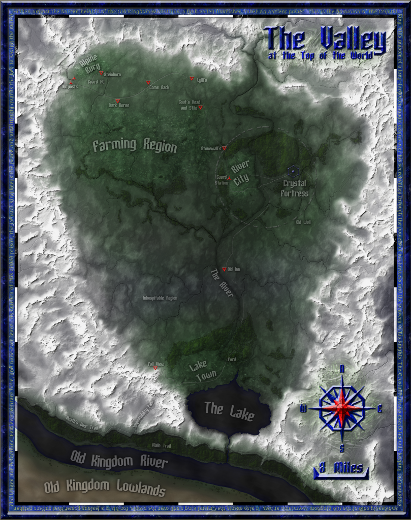
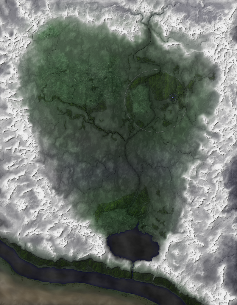
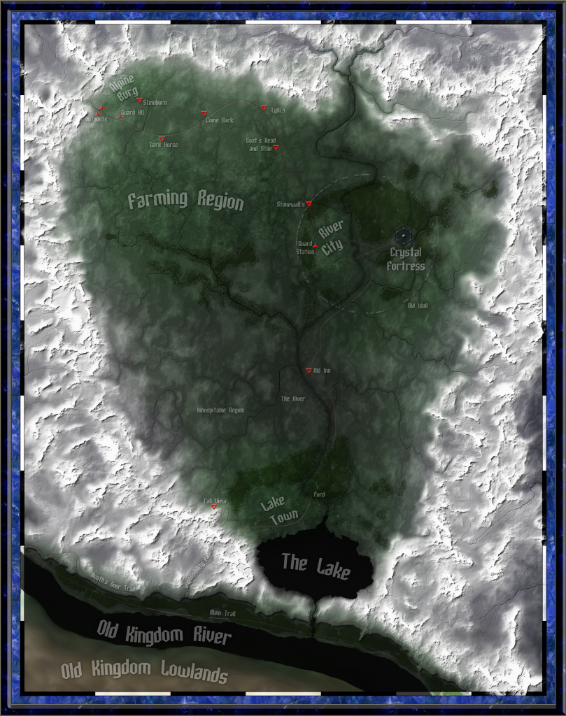
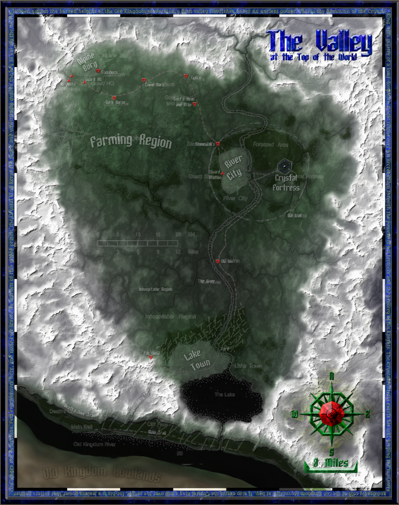
Map Project: Valley at the Top of the World (100% COMPLETE)

1st edition? 2nd edition? It doesnt matter! Let's just talk Palladium Fantasy.

Moderators: Immortals, Supreme Beings, Old Ones

User avatar
Hotrod
Knight
Posts: 3427
Joined: Fri Apr 13, 2001 1:01 am
Location: Orion Arm, Milky Way Galaxy

Map Project: Valley at the Top of the World (100% COMPLETE)

Unread post by Hotrod »


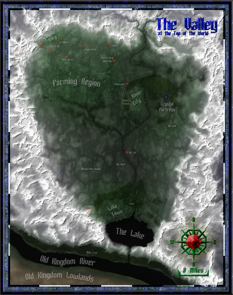
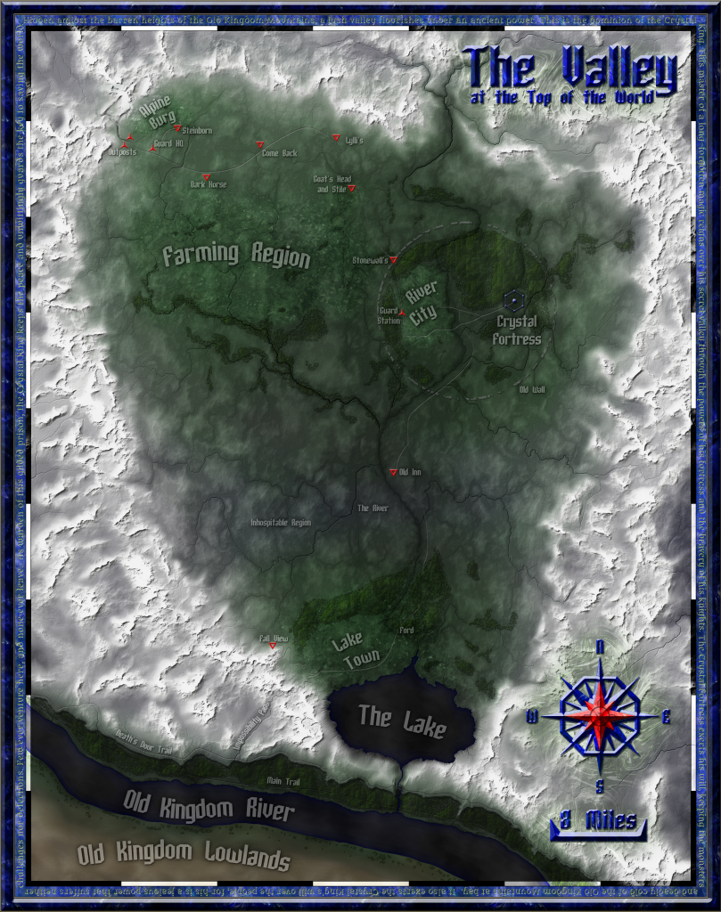
EDIT: (Previous edit) The rough draft of the map is finished.Although I've found plenty that needs fixing, I've been looking at this map for so long that it's easy to miss some pretty obvious errors. If you have the time, please look it over in detail and point out any errors or problems you see.


Zyanitevp, our coordinator of megaversal ambassadorship, game master of "A God... Rebuilt", and all-around Palladium super-fan, has commissioned me to make a map of the Valley at the Top of the World. The secret dominion of the Crystal King will be getting the full treatment.

Planned features:

+The map will be big enough to print on 8.5x11 inch paper at 300 dots per inch, which is about at photo-quality.
+The area portrayed will include the Valley and its immediate surroundings. The scale will be similar to that found on p50 of Island at the Edge of the World, but it'll include the mountains on all sides.
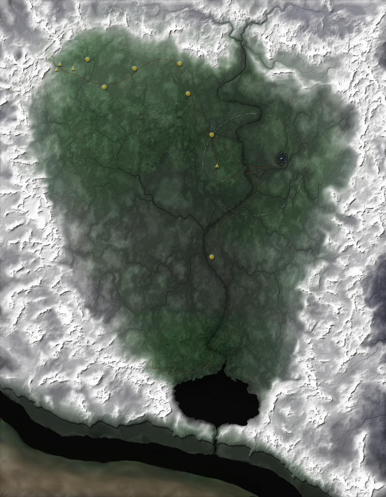
+Roads, towns, inns, and other places of interest will be marked. I plan on drawing the Crystal Fortress directly.
+The map will be fully colored/textured. I will attempt to show individual farms and woods.

I'll post in-progress shots here as I go.

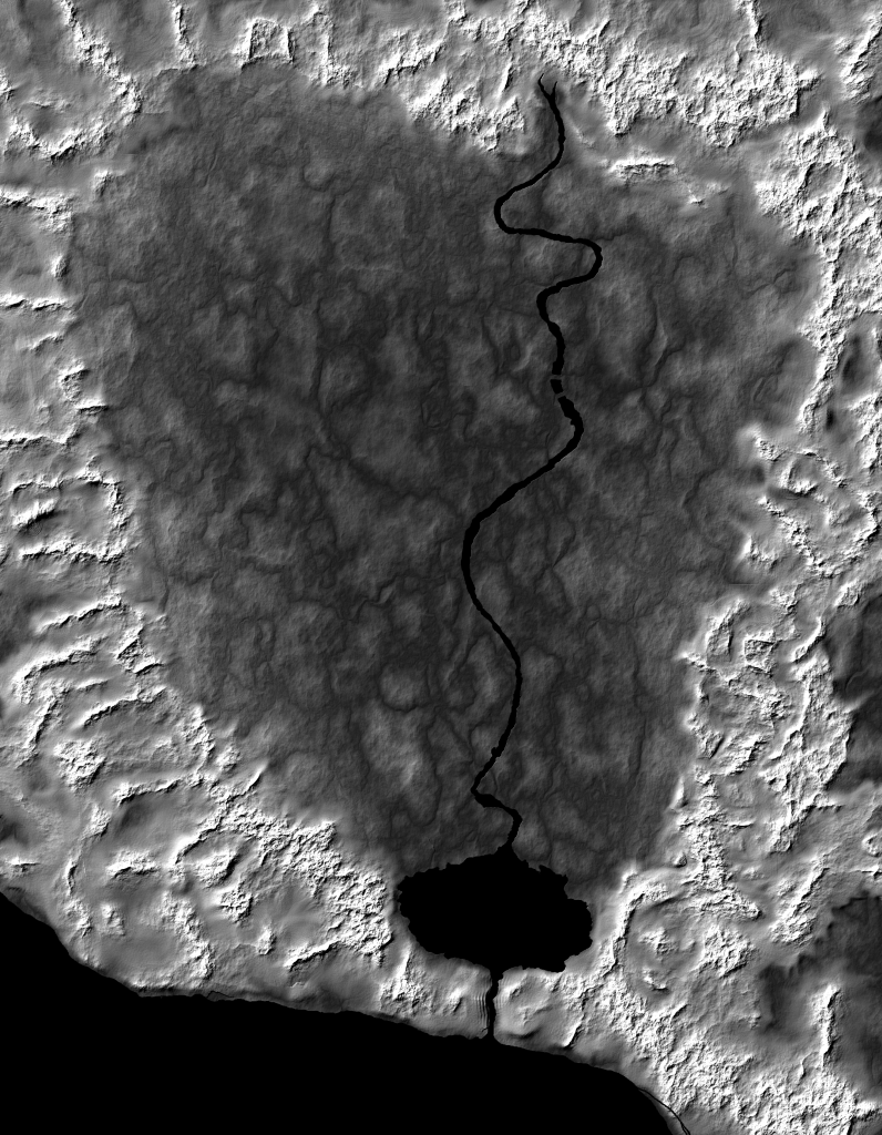
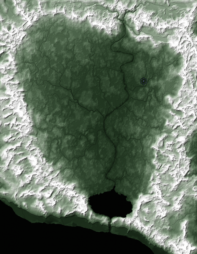
So far, I've researched the source maps and text, defined the scale and region to be mapped, and started working on the raw topography. Here's my initial draft of the land sculpt.I've done some airbrushing work to blend the mountains into the lowlands of the valley. There's plenty more to be done, including:
-I need to show a cliff face along the shore of the Old Kingdom River in the south. Cliffs are tricky to do from a top-down perspective, but I have some ideas.
-The surrounding mountains need some adjustment to make them look a bit more impassable.
-The Crystal Fortress is supposed to be in a depression. I need to draw this in, as well as the berm that surrounds it.
-The little river in the valley needs a lot of work. I drew it to match the page 50 map, but the detail map of River City depicts it as being much narrower than it appears on page 50. I'll also need to add in some tributaries.
-I plan on adding in a waterfall in the south where the little river runs over the cliff face.

Issues:
-The scaling of settlements in The Valley is really weird. All three towns take up huge amounts of space with relatively tiny populations.
-Several features are shown on the page 50 map, but are not described in the text: Impossibility Pass, Death's Door Trail, Main Trail, Fall View are the most-glaring.
-As noted above, the canon maps don't match up precisely. I'm using the most-zoomed-in-map-wins approach.
Last edited by Hotrod on Thu Jul 17, 2014 5:19 pm, edited 7 times in total.
Hotrod
Author, Rifter Contributor, and Map Artist
Duty's Edge, a Rifts novel. Available as an ebook, PDF,or printed book.
Check out my maps here!
Also, check out my Instant NPC Generators!
Like what you see? There's more on my Patreon Page.
Image
User avatar
pblackcrow
Champion
Posts: 2541
Joined: Sat Jul 13, 2002 1:01 am
Location: On Earth
Contact:

Re: Mapping Project: Valley at the Top of the World (20% Don

Unread post by pblackcrow »

Sorta like Hyperboria/Hyperborea in Greek myth and the Savage Lands in Marvel Comics.
Ankh, udja, seneb.
User avatar
Hotrod
Knight
Posts: 3427
Joined: Fri Apr 13, 2001 1:01 am
Location: Orion Arm, Milky Way Galaxy

Re: Mapping Project: Valley at the Top of the World (20% Don

Unread post by Hotrod »

Hyperborea is associated with extreme latitudes, is it not? The Vally at the Top of the World isn't that. It's a high-altitude valley in the Old Kingdom mountains that is strangely fertile and vibrant, even though it is well above timberline. The "Top of the World" in this case is more about altitude than latitude. Of course, it's far from the highest point on the Palladium Continent; the Great Barrier mountains are easily twice as high in many places.
Hotrod
Author, Rifter Contributor, and Map Artist
Duty's Edge, a Rifts novel. Available as an ebook, PDF,or printed book.
Check out my maps here!
Also, check out my Instant NPC Generators!
Like what you see? There's more on my Patreon Page.
Image
User avatar
zyanitevp
Champion
Posts: 1744
Joined: Sun Feb 13, 2011 2:13 am
Comment: Check out our Twitch stream!
Location: Sekti-Abtu

Re: Mapping Project: Valley at the Top of the World (20% Don

Unread post by zyanitevp »

I thought I remember it being stated that without the Crystal Palace the weather would change dramatically.
Thanks for taking this on! Should be very cool!
Broadcasting live twitchtv
My Twitter
Now Playing Savage Rifts as a Trimadore TechnoWizard
Image Image
User avatar
Hotrod
Knight
Posts: 3427
Joined: Fri Apr 13, 2001 1:01 am
Location: Orion Arm, Milky Way Galaxy

Re: Mapping Project: Valley at the Top of the World (20% Don

Unread post by Hotrod »

Quite right. The Crystal Fortress is the power behind The Valley's moderate climate.
Hotrod
Author, Rifter Contributor, and Map Artist
Duty's Edge, a Rifts novel. Available as an ebook, PDF,or printed book.
Check out my maps here!
Also, check out my Instant NPC Generators!
Like what you see? There's more on my Patreon Page.
Image
User avatar
pblackcrow
Champion
Posts: 2541
Joined: Sat Jul 13, 2002 1:01 am
Location: On Earth
Contact:

Re: Mapping Project: Valley at the Top of the World (20% Don

Unread post by pblackcrow »

Like the Atlantian Pyramids...

So more or less it's like Shangri La
Ankh, udja, seneb.
User avatar
Hotrod
Knight
Posts: 3427
Joined: Fri Apr 13, 2001 1:01 am
Location: Orion Arm, Milky Way Galaxy

Re: Mapping Project: Valley at the Top of the World (20% Don

Unread post by Hotrod »

That's a good analogy, yes.
Hotrod
Author, Rifter Contributor, and Map Artist
Duty's Edge, a Rifts novel. Available as an ebook, PDF,or printed book.
Check out my maps here!
Also, check out my Instant NPC Generators!
Like what you see? There's more on my Patreon Page.
Image
User avatar
The Dark Elf
Rifter® Contributer
Posts: 3074
Joined: Tue Sep 20, 2005 8:04 am
Comment: "So gentlemen, are you prepared to open your minds and travel to worlds hitherto undreamed of?"
Location: UK

Re: Mapping Project: Valley at the Top of the World (20% Don

Unread post by The Dark Elf »

zyanitevp wrote:I thought I remember it being stated that without the Crystal Palace the weather would change dramatically.
Thanks for taking this on! Should be very cool!


I went against the Crystal kings description and had him leave the palace to look at the newly found crystal gateway. the team then activated the gateway and barged him through it hundreds of miles away destroying the link/bond. They didnt realise what would happen to the weather and indeed the entire valley was caught in snow drifts and high winds causing some severe damage.
Rifter 52 Cannibal Magic
Rifter 55 The Ancestral Mystic P.C.C.
Rifter 59 The Lopanic Games adventure "The Lion, the Ditch & the Warlock". Illustrations to this adventure can be found here.
Rifter 71 & 72 Double Issue Ninjas & Superspies adventure "On a Wing & a Prayer"
Rifter 80 Masters Unlimited
User avatar
Hotrod
Knight
Posts: 3427
Joined: Fri Apr 13, 2001 1:01 am
Location: Orion Arm, Milky Way Galaxy

Re: Mapping Project: Valley at the Top of the World (20% Don

Unread post by Hotrod »

Update: The Land Sculpt is done (though I have one glaring error to fix). Here is the current draft.

New features:

+I added rivers and streams, and I removed the wide, ugly river I had in the previous draft. The valley river in the book's Valley map was much wider than it was on the River City map, so I opted to go with the closer-scaled River City. The central river in the valley is a close match for the canon map. The other little tributaries are intended to be small streams that can be easily crossed at most points. Their locations and flow patterns are driven by the terrain, with the biggest one flowing through the valley's farm country.
+Cliffs! The southern mountains are supposed to plunge down quite dramatically toward the Old Kingdom River. I'm playing around with a couple of techniques to get the right look.
+The Crystal Fortress, drawn partly to scale. The central keep and corner towers are a bit wider than described, but the outer walls are the correct length and alignment. The distortions were necessary, otherwise they'd just be dots, and I wanted this structure big enough to show its crystal facets. As described in the book, the fortress is in a small depression (the hole they dug to uncover it 1000 years ago). The dimensions of the depression should be accurate.

Known Discrepancies:
-The fortress is blue on the map. Although the fortress is described in the book as shimmering with many colors, this isn't practical to show. I chose blue based on the alignment color scheme of crystal swords described in the book. The dominant personality of the fortress is Anarchist and paranoid (which is kind of evil), but it wants to keep things in the valley peaceful. Since dark blue is associated with evil and warlike natures, and light blue is associated with peace loving, an intermediate deep blue seemed symbolically appropriate.

-Mountain placement and shape isn't a precise match to the upside-down V's shown on the various source maps. I superimposed and re-sized the published maps against each other; they don't come close to matching. Therefore, I just put mountains in the mountain regions and tried to make them look intimidating and impassable.

The Old Kingdom river at the south of the map is over 10 miles wide in this draft. There should be a south bank on the map. It was a silly oversight on my part that I just noticed. I'll fix it.

Still to do:

-Climate Zones. I threw a green one in here, but there need to be more.
-Terrain details: I'm thinking roads, bridges, towns, farms, and trees.
-Labels
-The usual extras: Frame, compass rose, legend, and scale. I'm contemplating how I'll customize them to the themes of this map.
-Final tweaks.
Hotrod
Author, Rifter Contributor, and Map Artist
Duty's Edge, a Rifts novel. Available as an ebook, PDF,or printed book.
Check out my maps here!
Also, check out my Instant NPC Generators!
Like what you see? There's more on my Patreon Page.
Image
User avatar
zyanitevp
Champion
Posts: 1744
Joined: Sun Feb 13, 2011 2:13 am
Comment: Check out our Twitch stream!
Location: Sekti-Abtu

Re: Mapping Project: Valley at the Top of the World (30% Don

Unread post by zyanitevp »

Coming together nicely!
Broadcasting live twitchtv
My Twitter
Now Playing Savage Rifts as a Trimadore TechnoWizard
Image Image
User avatar
kiralon
Champion
Posts: 2804
Joined: Wed Jan 25, 2012 10:05 pm
Comment: Kill it with Fire.

Re: Mapping Project: Valley at the Top of the World (30% Don

Unread post by kiralon »

+1
Good Job
User avatar
Hotrod
Knight
Posts: 3427
Joined: Fri Apr 13, 2001 1:01 am
Location: Orion Arm, Milky Way Galaxy

Re: Mapping Project: Valley at the Top of the World (20% Don

Unread post by Hotrod »

Update: Lots of little changes since the last posting.Here is the current draft.

New features:

+The Old Kingdom River now has a south shore. In keeping with the canon description of the Old Kingdom as being a fairly desolate wasteland, so I gave it a desert-ish, eroded look. The north side is green, since it gets irrigated by streams coming down from the mountains.

Climate Zones. I added a green temperate for the valley, a tundra to help accentuate the mountains, and a couple of desert layers for the south side of the Old Kingdom River to the south.

+The Ruined Stone Wall
is now a physical object, with some randomized holes (and a few deliberate ones) to show its wear and tear.

+The communities have some farmland textures added, with a little help from Google Earth and some spots in the middle of Wales.

Roads and Icons. I've drafted them. I'm not very happy with their overall look, but their placement is accurate. The triangles are guard stations, and the circles are inns.


Known Discrepancies:
-The fortress is blue on the map. Although the fortress is described in the book as shimmering with many colors, this isn't practical to show. I chose blue based on the alignment color scheme of crystal swords described in the book. The dominant personality of the fortress is Anarchist and paranoid (which is kind of evil), but it wants to keep things in the valley peaceful. Since dark blue is associated with evil and warlike natures, and light blue is associated with peace loving, an intermediate deep blue seemed symbolically appropriate.

-Mountain placement and shape isn't a precise match to the upside-down V's shown on the various source maps. I superimposed and re-sized the published maps against each other; they don't come close to matching. Therefore, I just put mountains in the mountain regions and tried to make them look intimidating and impassable.

Impossibility Pass, Death's Door Trail, and Main Trail aren't on the map.
I haven't figured out how to do these yet; I'll put them in once I've revised the roads/icons.


Still to do:

-Terrain details: I still need to add trees, revise the icons/roads, touch up the cliffs, and add a waterfall effect.
-Labels
-The usual extras: Frame, compass rose, legend, and scale. I'm contemplating how I'll customize them to the themes of this map.
-Final tweaks.[/quote]
Hotrod
Author, Rifter Contributor, and Map Artist
Duty's Edge, a Rifts novel. Available as an ebook, PDF,or printed book.
Check out my maps here!
Also, check out my Instant NPC Generators!
Like what you see? There's more on my Patreon Page.
Image
User avatar
zyanitevp
Champion
Posts: 1744
Joined: Sun Feb 13, 2011 2:13 am
Comment: Check out our Twitch stream!
Location: Sekti-Abtu

Re: Mapping Project: Valley at the Top of the World (30% Don

Unread post by zyanitevp »

Loving this! The wall is a great touch!
Broadcasting live twitchtv
My Twitter
Now Playing Savage Rifts as a Trimadore TechnoWizard
Image Image
User avatar
Hotrod
Knight
Posts: 3427
Joined: Fri Apr 13, 2001 1:01 am
Location: Orion Arm, Milky Way Galaxy

Re: Mapping Project: Valley at the Top of the World (30% Don

Unread post by Hotrod »

Thanks! I've re-done the icons and roads, and I'm working on labels and forests now. It's almost a functional (though unpolished) map.

I'll put up another in-progress shot when the woods are done.
Hotrod
Author, Rifter Contributor, and Map Artist
Duty's Edge, a Rifts novel. Available as an ebook, PDF,or printed book.
Check out my maps here!
Also, check out my Instant NPC Generators!
Like what you see? There's more on my Patreon Page.
Image
User avatar
Hotrod
Knight
Posts: 3427
Joined: Fri Apr 13, 2001 1:01 am
Location: Orion Arm, Milky Way Galaxy

Update!

Unread post by Hotrod »

Update: I've added a number of elements and revised others.Here is the current draft.

New features:

+Woods. The main concentrations are in the canon locations which are on the north side of River City but inside the wall, and in the south around Lake Town. I also added woods along the northern bank of the Old Kingdom River. The south side is more wasteland-ish, but I figure that the north side benefits from mountain streams, hence the vegetation. I need to add a few scattered trees in some places, but I'm satisfied with the overall look.

+Revamped Icons. I made them red this time, and gave them two distinctive shapes that don't obscure as much terrain.

+Labels are in. I went with an angular free-use font, "SF Archery Black", with a semi-transparent look to show more underlying terrain.

+Roads have been revamped, with some added texture. I also added Death's Door Trail, the Main Trail, and Impossibility Pass.

+I've added a frame. I gave it a deep blue crystal look to match the Fortress.

Known Discrepancies:
-The fortress is blue on the map. Although the fortress is described in the book as shimmering with many colors, this isn't practical to show. I chose blue based on the alignment color scheme of crystal swords described in the book. The dominant personality of the fortress is Anarchist and paranoid (which is kind of evil), but it wants to keep things in the valley peaceful. Since dark blue is associated with evil and warlike natures, and light blue is associated with peace loving, an intermediate deep blue seemed symbolically appropriate.

-Mountain placement and shape isn't a precise match to the upside-down V's shown on the various source maps. I superimposed and re-sized the published maps against each other; they don't come close to matching. Therefore, I just put mountains in the mountain regions and tried to make them look intimidating and impassable. I may tweak the main entrance in the northwest to match the text description later.

There's a small section of road missing in Alpine Burg, the part leading to the Steinburg Inn Oops. I'll fix it during the final tweaks.


Still to do:

-Frame Inscription.
-Terrain details: I still need to touch up the cliffs and add a waterfall effect.
-The usual extras: A compass rose, legend, and scale.
-Final tweaks.
Last edited by Hotrod on Fri Jul 04, 2014 12:40 pm, edited 1 time in total.
Hotrod
Author, Rifter Contributor, and Map Artist
Duty's Edge, a Rifts novel. Available as an ebook, PDF,or printed book.
Check out my maps here!
Also, check out my Instant NPC Generators!
Like what you see? There's more on my Patreon Page.
Image
User avatar
zyanitevp
Champion
Posts: 1744
Joined: Sun Feb 13, 2011 2:13 am
Comment: Check out our Twitch stream!
Location: Sekti-Abtu

Re: Mapping Project: Valley at the Top of the World (60% Don

Unread post by zyanitevp »

The progression has been fascinating!
Like how the red pops more than the yellow did- good choice.
Awesome frame, really ties it together.
Looking great!
Broadcasting live twitchtv
My Twitter
Now Playing Savage Rifts as a Trimadore TechnoWizard
Image Image
User avatar
Hotrod
Knight
Posts: 3427
Joined: Fri Apr 13, 2001 1:01 am
Location: Orion Arm, Milky Way Galaxy

Re: Mapping Project: Valley at the Top of the World (60% Don

Unread post by Hotrod »

UPDATE: The rough draft of the map is complete. All elements are in place, though there's plenty of touching up to do.

If you have the time/interest, I need your help! Now is the time for nit-picking as I try to find and fix every error and tweak features to make the final product look as good and as accurate as possible. Please go over these maps and the book (if you own/can find a copy) and point out anything you see that might be wrong or need improvement.

Here is the current version of the map.

Here is the current version with the main source map from Island at the Edge of the World superimposed.

New Features:

+I added a compass rose and scale. I opted for a green look. Since Archie is the principal guiding NPC of the book, it seemed symbolically appropriate to color the compass rose and scale according to his crystal sword's core, which is green. I tried adding a subtle yellow swirly effect behind the compass, too. I chose the red crystal in the middle based on his sword in the cover art, and I added in a rune of mystical forces for fun.

+I added a title and tried to give it a deep blue crystal look. The SF Archery black font's hard angles worked nicely here for the look.

+I added an inscription to the frame. For those who don't care to read sideways and upside-down, it reads, “Hidden amidst the barren heights of the Old Kingdom Mountains, a lush valley flourishes under an ancient power. This is the dominion of the Crystal King. This master of a long-forgotten magic reigns over his secret valley through the powers of his fortress and the bravery of his knights. The Crystal Fortress exerts his will, keeping the monsters and deadly cold of the Old Kingdom Mountains at bay. It also exerts the Crystal King's will over the people, for his is a jealous power that suffers neither challenges nor defections. Few ever venture here, and none ever leave. As warden of this gilded prison, the Crystal King keeps the peace and unwittingly guards the key to saving the world.”

At this point, the map is functionally complete. Unless someone spots a glaring omission, I do not intend to add more features to the map. That said, this project is not yet complete. My approach with this map was to make each feature "good enough" to continue, then come back later to fine tune it. As such, there are a lot of little things to be done. If you see any that aren't on the list below, please point them out to me.

Intended Fixes, Tweaks, and Improvements.
-The title text letters are packed together too closely. I'll widen them out a bit.
-The map needs more scattered trees, especially in the south. I'll probably add a few to the southern shore; I don't want it being a straight-up desert at the shore.
-The compass rose needs to be reworked so its highlights match the title text and scale.
-I may change the green of the compass rose and scale to blue; I'm concerned that the saturated green and blue color combination detracts from the aesthetics. I'll either ditch or emphasize the yellow swirl background.
-The central crystal of the compass rose seems too big and too simple. I'm not sure if I should re-size, re-shape, or totally replace it, but I feel like some kind of structural change is in order.
-The River's label should move along with the river. It should probably be bigger, too. I'll fix it.
-The cliffs are too regular. I need to adjust the shadows to make them look more irregular and natural.
-The water needs texture and color work, especially the wider spots like the lake and Old Kingdom River.
-The waterfall south of The Lake needs to be defined with some kind of technique or effect, like a bit of cloud or something. As it is now, it looks like you could just paddle into The Lake from the Old Kingdom River.
-There's no road going to Steinborn in the north. There should be. I'll fix it.
-The main entrance to the valley doesn't match the canon description. There should be a deep, narrow canyon that winds a bit before it opens up into the main path.
-The barren area north of Lake Town needs more attention. It should look a bit colder, with a bit of scrub. I'll blend in a bit of arctic gradient and add a few scattered trees.
-The period at the end of the inscription is missing. Oops. I'll fix it.
-There is no legend. I'm not sure if it would improve the map to add one, since there are only two types of icons, and each spot is labeled.
-Colors and shading will need some final re-balancing after everything else is done.

Known Discrepancies:
-The fortress is blue on the map. Although the fortress is described in the book as shimmering with many colors, this isn't practical to show. I chose blue based on the alignment color scheme of crystal swords described in the book. The dominant personality of the fortress is Anarchist and paranoid (which is kind of evil), but it wants to keep things in the valley peaceful. Since dark blue is associated with evil and warlike natures, and light blue is associated with peace loving, an intermediate deep blue seemed symbolically appropriate.

-Mountain placement and shape isn't a precise match to the upside-down V's shown on the various source maps. I superimposed and re-sized the published maps against each other; they don't come close to matching. Therefore, I just put mountains in the mountain regions and tried to make them look intimidating and impassable.
Last edited by Hotrod on Wed Jul 16, 2014 9:46 pm, edited 4 times in total.
Hotrod
Author, Rifter Contributor, and Map Artist
Duty's Edge, a Rifts novel. Available as an ebook, PDF,or printed book.
Check out my maps here!
Also, check out my Instant NPC Generators!
Like what you see? There's more on my Patreon Page.
Image
User avatar
zyanitevp
Champion
Posts: 1744
Joined: Sun Feb 13, 2011 2:13 am
Comment: Check out our Twitch stream!
Location: Sekti-Abtu

Re: Mapping Project: Valley at the Top of the World (60% Don

Unread post by zyanitevp »

Hotrod wrote:UPDATE: The rough draft of the map is complete. All elements are in place, though there's plenty of touching up to do.

If you have the time/interest, I need your help! Now is the time for nit-picking as I try to find and fix every error and tweak features to make the final product look as good and as accurate as possible. Please go over these maps and the book (if you own/can find a copy) and point out anything you see that might be wrong or need improvement.

Here is the current version of the map.

Here is the current version with the main source map from Island at the Edge of the World superimposed.

Intended Fixes, Tweaks, and Improvements.
-The title text letters are packed together too closely. I'll widen them out a bit.
-The map needs more scattered trees, especially in the south. I'll probably add a few to the southern shore; I don't want it being a straight-up desert at the shore.
-The compass rose needs to be reworked so its highlights match the title text and scale.
-I may change the green of the compass rose and scale to blue; I'm concerned that the saturated green and blue color combination detracts from the aesthetics. I'll either ditch or emphasize the yellow swirl background.
-The central crystal of the compass rose seems too big and too simple. I'm not sure if I should re-size, re-shape, or totally replace it, but I feel like some kind of structural change is in order.
-The River's label should move along with the river. It should probably be bigger, too. I'll fix it.
-The cliffs are too regular. I need to adjust the shadows to make them look more irregular and natural.
-The water needs texture and color work, especially the wider spots like the lake and Old Kingdom River.
-The waterfall south of The Lake needs to be defined with some kind of technique or effect, like a bit of cloud or something. As it is now, it looks like you could just paddle into The Lake from the Old Kingdom River.
-There's no road going to Steinborn in the north. There should be. I'll fix it.
-The main entrance to the valley doesn't match the canon description. There should be a deep, narrow canyon that winds a bit before it opens up into the main path.
-The barren area north of Lake Town needs more attention. It should look a bit colder, with a bit of scrub. I'll blend in a bit of arctic gradient and add a few scattered trees.
-The period at the end of the inscription is missing. Oops. I'll fix it.
-There is no legend. I'm not sure if it would improve the map to add one, since there are only two types of icons, and each spot is labeled.
-Colors and shading will need some final re-balancing after everything else is done.


Looks awesome!
No legend needed. I agree that blue may be a better color for the compass rose.
Broadcasting live twitchtv
My Twitter
Now Playing Savage Rifts as a Trimadore TechnoWizard
Image Image
User avatar
Hotrod
Knight
Posts: 3427
Joined: Fri Apr 13, 2001 1:01 am
Location: Orion Arm, Milky Way Galaxy

Re: Map Project: Valley at the Top of the World (100% done)

Unread post by Hotrod »

The map is finished. All planned fixes and tweaks are complete, though if someone points out a significant error, I'll adjust accordingly.

Here is the final version of the map.

Here is a raw geography version without icons or labels.

I re-touched and re-did a number of features. This included all the tweaks I mentioned in my last update, plus a few others.

Barring any issues that come to my attention, that wraps this map up! I had a lot of fun researching as I read through the excellent "Island at the Edge of the World" campaign book, and I used all the cartography tricks I know to bring this Palladium Fantasy Shangri-La to life. I also explored a few new techniques for this map, like the real-world imagery for the towns and farmland, as well as the cliffs.

I hope you fellow Palladium Fantasy fans find this useful, or failing that, nice to look at. If you have the time and inclination, I'd love to hear what you think of it, regardless of whether you like it, love it, or "meh" it.
Last edited by Hotrod on Thu Jul 17, 2014 5:20 pm, edited 1 time in total.
Hotrod
Author, Rifter Contributor, and Map Artist
Duty's Edge, a Rifts novel. Available as an ebook, PDF,or printed book.
Check out my maps here!
Also, check out my Instant NPC Generators!
Like what you see? There's more on my Patreon Page.
Image
User avatar
kiralon
Champion
Posts: 2804
Joined: Wed Jan 25, 2012 10:05 pm
Comment: Kill it with Fire.

Re: Map Project: Valley at the Top of the World (100% COMPLE

Unread post by kiralon »

Bloody awesome job, wish id had your map when I was dm'ing that campaign, would have printed it a1 and laminated it and stuck it up on the wall.
User avatar
zyanitevp
Champion
Posts: 1744
Joined: Sun Feb 13, 2011 2:13 am
Comment: Check out our Twitch stream!
Location: Sekti-Abtu

Re: Map Project: Valley at the Top of the World (80% done)

Unread post by zyanitevp »

Hotrod wrote:The map is finished. All planned fixes and tweaks are complete, though if someone points out a significant error, I'll adjust accordingly.

Here is the final version of the map.

Here is a raw geography version without icons or labels.

I re-touched and re-did a number of features. This included all the tweaks I mentioned in my last update, plus a few others.

Barring any issues that come to my attention, that wraps this map up! I had a lot of fun researching as I read through the excellent "Island at the Edge of the World" campaign book, and I used all the cartography tricks I know to bring this Palladium Fantasy Shangri-La to life. I also explored a few new techniques for this map, like the real-world imagery for the towns and farmland, as well as the cliffs.

I hope you fellow Palladium Fantasy fans find this useful, or failing that, nice to look at. If you have the time and inclination, I'd love to hear what you think of it, regardless of whether you like it, love it, or "meh" it.

Looks awesome!! Better than I had hoped for! Well done!
Broadcasting live twitchtv
My Twitter
Now Playing Savage Rifts as a Trimadore TechnoWizard
Image Image
User avatar
zyanitevp
Champion
Posts: 1744
Joined: Sun Feb 13, 2011 2:13 am
Comment: Check out our Twitch stream!
Location: Sekti-Abtu

Re: Map Project: Valley at the Top of the World (100% COMPLE

Unread post by zyanitevp »

kiralon wrote:Bloody awesome job, wish id had your map when I was dm'ing that campaign, would have printed it a1 and laminated it and stuck it up on the wall.

You will soon be able to have it up on the wall, as your player character will visit there....
Broadcasting live twitchtv
My Twitter
Now Playing Savage Rifts as a Trimadore TechnoWizard
Image Image
User avatar
Hotrod
Knight
Posts: 3427
Joined: Fri Apr 13, 2001 1:01 am
Location: Orion Arm, Milky Way Galaxy

Re: Map Project: Valley at the Top of the World (100% COMPLE

Unread post by Hotrod »

Thanks for the kind words! I hope you find the map useful in your adventures.

The map has enough definition to print at 300dpi+ on a standard 8.5" x 11" piece of paper, though it may need some lightening, as images tend to look darker in print (I haven't tried printing it yet). It also looks good on a big HDTV, if you have the right hardware.
Hotrod
Author, Rifter Contributor, and Map Artist
Duty's Edge, a Rifts novel. Available as an ebook, PDF,or printed book.
Check out my maps here!
Also, check out my Instant NPC Generators!
Like what you see? There's more on my Patreon Page.
Image
User avatar
Hotrod
Knight
Posts: 3427
Joined: Fri Apr 13, 2001 1:01 am
Location: Orion Arm, Milky Way Galaxy

Re: Map Project: Valley at the Top of the World (100% COMPLE

Unread post by Hotrod »

Mini-update. I noticed that I had an older version of the labels on that map. I fixed it and updated the link. The River now has a bigger label that follows its course.
Hotrod
Author, Rifter Contributor, and Map Artist
Duty's Edge, a Rifts novel. Available as an ebook, PDF,or printed book.
Check out my maps here!
Also, check out my Instant NPC Generators!
Like what you see? There's more on my Patreon Page.
Image
URLeader Hobbes
Explorer
Posts: 143
Joined: Fri Sep 09, 2011 9:25 am

Re: Map Project: Valley at the Top of the World (100% COMPLE

Unread post by URLeader Hobbes »

Wow that's excellent! Amazing job! You should get hired by PB to do some more maps for updated reissues!
Post Reply

Return to “Palladium Fantasy RPG®”